First it was vicious Hurricane Beulah. Then scores of tornadoes combined with torrential rains.
Finally, the most devastating floods in Texas' history.
WHY did it happen — and what does it mean?
Read the answer in this on-the-spot report from our Texas staff.
IT IS NOW admitted. One billion dollars estimated property damage. Hundreds of homes obliterated by hurricane winds. Thousands more devastatingly flooded by 10-foot tides, crashing waves and twenty-inch-plus rains — on the heels of a severe drought.
Electrical and communications systems "damaged unbelievably." Millions of dollars' worth of citrus fruit, just in the beginning stages of harvest, knocked to the ground; numerous fruit trees uprooted and destroyed. At least seventy tornadoes (some reports said more than 100) spawned in the aftermath.
|
Duncan, Walter — Ambassador College
Floodwater, demolished buildings, torn-up pavements as far as the eye can see — havoc wrought when
Hurricane Beulah unleashed her fury on South Texas and adjoining Mexico.
|
Countless Thousands Hit
At least one million people isolated or immobilized. And 250,000 driven from their homes to emergency shelters in Texas alone (to say nothing of Mexico) at the height of Beulah's fury.
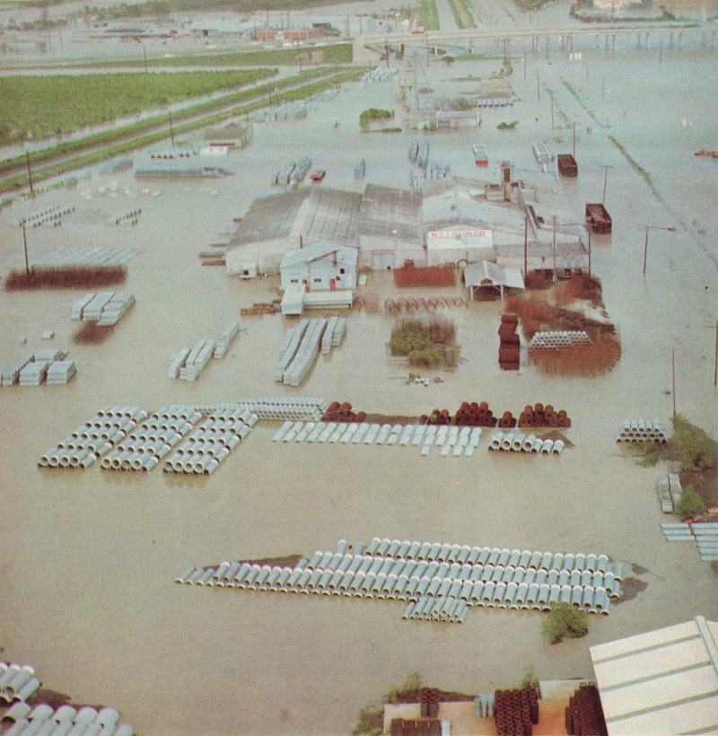
Forty thousand square miles of land — an area equivalent to the entire state of Kentucky or larger than the combined area of Scotland and Wales — virtually one gigantic, marshy lake!
News commentator Porter Randall thus described the disaster: "Hurricane Beulah has created a tragedy the like of which Texas has never seen before."
Director of the National Hurricane Center in Miami, R.H. Simpson, acknowledged that Beulah was one of the three most powerful hurricanes of this century, and that her flooding was the worst in history ever caused by a hurricane.
Officials of the Office of Emergency Planning said that the sheltering and feeding of the refugees was "probably the greatest rescue operation for a natural disaster in history."
Beulah's Destructive Arrival
For more than two weeks Beulah had been building up steam in the Caribbean — wreaking havoc and death wherever she touched land. Then on the morning of September 20 she ripped into South Texas near the U.S. Mexican border in the general area of Brownsville.
Port Isabel, a coastal resort community of 5,000, was in the direct line of Beulah's 160-mile-per-hour fury. All but five or six of the residents had evacuated — and it was a good thing. Port Isabel was mostly a heap of wreckage when Beulah left.
Erratic Beulah next headed inland toward the northwest. She slammed into the northern edge of the rich Rio Grande Valley and savagely attacked the citrus orchards.
By late evening Beulah had worked herself inland over ranch country and was beginning to lose her punch.
But the worst was yet to come.
The Morning After
As soon as it was light the next morning (Thursday), PLAIN TRUTH staff members began a survey of the disaster area by car. An aerial survey was impossible at this time because the sky was dark and foreboding. Radio broadcasts were warning continually to be on the alert for tornadoes throughout the entire area.
Port Isabel was about 125 miles south of Kingsville, our departure point that morning. The first 75 miles of this distance on U.S. Highway 77 is through very lightly populated ranch country — formerly the famous King Ranch.
On this morning after the hurricane, however, little land was to be seen. It was mostly one high, swampy lake. Cattle could be seen hovering together on the few available patches of high ground. Most of the time the water was right up to the road's edge. Frequently it overflowed the highway by five or six inches.
Finally we arrived in Raymondville, a small city of 10,000 on the northern perimeter of the valley's cultivated area. It was here that the scope of the destruction began to hit us.
In Raymondville
Snagged, snarled power lines; snapped utility poles; denuded and uprooted trees and shrubbery; wrecked signs and billboards; buildings with windows knocked out and part of the roof gone — these were the sights that met the eye in all directions.
And everywhere — water. Dirty water. Water with jagged and splintered debris sticking out of it.
Dark and heavy clouds cast a pall over the city like a suffocating blanket. Occasionally they unleashed torrents of rain. To add to the gloominess of this unnatural, midmorning darkness, the city was without lights. It was without electric power and telephone service.
We tried to buy gasoline — but there was no electric power to operate the pumps.
There were no usable toilet facilities the sewerage system was out.
The water was not safe to drink. We finally found a small grocery store that had a few gallons of bottled water. This drinkable water and the store's few remaining items of groceries were being sold fast. Several inches of water covered the floor.
Across the street, we discovered a gasoline station that was just opening for business. Electricity had somehow been restored to the hospital, and this station happened to be on the same line as the hospital.
As we filled with fuel, one man was cursing because he had been refused shelter at one of the churches during the hurricane. He was a member of the same general denomination as this church, but he was not a member of that particular church, so he was turned away. He went back home and rode out the hurricane there.
South of Raymondville, the evidences of destruction were even greater. Damage to buildings and power lines appeared more extensive. Cultivated fields were filled with water and the citrus groves were flooded up to the lowest branches of the trees.
At Highway 100, we turned east to travel the final twenty miles to Port Isabel. Most of this highway was under several inches of water, and the land surrounding the highway was almost completely inundated. Travel was slow.
At Port Isabel
We arrived at Port Isabel about noon and were stopped at the town's entrance by the National Guard. No one was being allowed entrance except returning residents and newsmen. We showed our credentials and were admitted.
Main Street was an unbelievable maze of destruction. On one street a jeep was overturned. On another a huge houseboat with pontoons lay on its side and blocked the entire street.
An estimated 85 percent of the structures in town were destroyed, and all others were damaged.
Some of the residents who had returned were armed and on the lookout for looters. What one would loot and where you would take it I never quite figured out.
At the National Guard's temporary base, we were introduced to Captain Sanders and Mayor Leo Sanders who were both most helpful and courteous to us. They filled us in on many details and personally allowed us entrance to Padre Island.
On Padre Island
Padre Island is separated from the mainland and Port Isabel by a three-mile causeway. A bridge on the causeway had been damaged, and for fear of damaging it further, not even residents of the island were being allowed to pass over the causeway. Only police officials and a few newsmen were allowed passage. Mayor Sanders was kind enough to give us personal permission and we were among the first to cross over to the island.
The south part of this island has between 200 and 250 year-round residents, many of whom live in a trailer court at the southern tip.
This trailer court was obliterated. The Department of Public Safety said that 112 out of the 116 trailer homes had been destroyed. We didn't see any that were not destroyed, though a few may not have been.
And by "destroyed" I don't mean just lightly tipped over. I mean shattered. The difference in air pressure when the hurricane struck caused many of these homes to literally explode. What remained was just a mangled heap of rubbish.
Other facilities on this island resort were likewise extensively damaged.
The Flooding Begins
From Port Isabel, we drove to Brownsville. This road was even more flooded and in spots along the ocean where the tides had come crashing in, it was completely washed out.
Brownsville, (population 50,000) though not in the most direct path of Beulah, had sustained heavy damage and was already in the midst of a $120,000 cleanup operation.
As we left Brownsville and headed up the valley, it began to rain very hard! Suddenly we found ourselves in very deep water — literally!
Radio reports said that the entire region for several hundred miles north was now under torrential rains. More than twenty inches had fallen in some areas and roads were being closed. This deluge was about the same as the average annual rainfall over much of this area!
Immediately we headed for Harlingen to the north, but heavily flooded roads made travel slow. The land was unbelievably level and water was everywhere.
In Harlingen the Department of Public Safety told us that if we had any hopes of getting out we had better head north to U.S. 77 immediately — that it might already be too late.
As we followed another car on a spur road leading to U.S. 77, we suddenly found ourselves in water up to the bumper. To make matters worse, it was raining furiously and the water was so deep that all roadside markers had disappeared. It was impossible to turn around, and unless we kept moving, the car would stall. There was only one thing to do: head for the traffic light that was hanging above the road about a quarter of a mile away and hope that the road didn't bend anywhere in between!
Thankfully, we made it through this difficult stretch and onto the main highway. But even the main road was seriously flooded now and driving was hazardous.